Uttarakhand , a hill state in north India, is spread over 58,484 square kilometers. The state is located between 30° 33′ N and 78°06′ E. Uttaranchal is bounded by Himachal Pradesh in the west and by Uttar Pradesh in the south. The state shares an international boundary with two countries; in the north with China, and in the east with Nepal.
Most of Uttaranchal falls in the southern slopes of the Himalayas, but it also has some areas in the plains. The plain areas are called the Terai. About 64% of the state is forested.
The state has two divisions of Garhwal and Kumaon, and is further divided into thirteen districts. The districts which fall in Garhwal division are Dehradun, Haridwar, Chamoli, Rudraprayag, Tehri Garhwal, Uttarkashi, and Pauri Garhwal. These districts have some of the highest Himalayan peaks located here. The districts which are a part of Kumaon division are Almora, Nainital, Pithoragarh, Udham Singh Nagar, Bageshwar, and Champawat. Most of the tourist hill towns in the state are located in the Kumaon Division.
Uttarkashi district, in the Himalayas, is the home of the source of two most important rivers in the country-the Ganges and the Yamuna. The Hindu pilgrim points of Char Dham fall in this district. Udham Singh Nagar district lies in the Terai plains. The famous Jim Corbett Tiger reserve is located in the Nainital district. The world Heritage Nanda Devi Park is located in Chamoli district.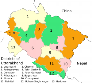
The state capital is at Dehradun. Other important towns and district headquarters are Nainital, Haridwar, and Almora. Dehradun is an important rail connection for the entire state as it lies on the route of the Northern Railway line. For the Kumaon division, Kathgodam town is the last terminus of the broad gauge line for the North eastern railways.
The state has airports in Dehradun in Dehradun district and Pant Nagar in Udham Singh Nagar District.
List of Districts in Uttarakhand
| Sr. No. | District | District HQ | Population (2011) | Growth | Sex Ratio | Literacy | Area (km2) | Density (/km2) |
| 1 | Almora | Almora | 622506 | -1.28% | 1139 | 80.47 | 3090 | 198 |
| 2 | Bageshwar | Bageshwar | 259898 | 4.18% | 1090 | 80.01 | 2310 | 116 |
| 3 | Chamoli | Gopeshwar | 391605 | 5.74% | 1019 | 82.65 | 7692 | 49 |
| 4 | Champawat | Champawat | 259648 | 15.63% | 980 | 79.83 | 1781 | 147 |
| 5 | Dehradun | Dehradun | 1696694 | 32.33% | 902 | 84.25 | 3088 | 550 |
| 6 | Haridwar | Haridwar | 1890422 | 30.63% | 880 | 73.43 | 2360 | 817 |
| 7 | Nainital | Nainital | 954605 | 25.13% | 934 | 83.88 | 3853 | 225 |
| 8 | Pauri Garhwal | Pauri | 687271 | -1.41% | 1103 | 82.02 | 5438 | 129 |
| 9 | Pithoragarh | Pithoragarh | 483439 | 4.58% | 1020 | 82.25 | 7110 | 69 |
| 10 | Rudraprayag | Rudraprayag | 242285 | 6.53% | 1114 | 81.3 | 1896 | 119 |
| 11 | Tehri Garhwal | New Tehri | 618931 | 2.35% | 1077 | 76.36 | 4085 | 169 |
| 12 | Udham Singh Nagar | Rudrapur | 1648902 | 33.45% | 920 | 73.1 | 2912 | 648 |
| 13 | Uttarkashi | Uttarkashi | 330086 | 11.89% | 958 | 75.81 | 7951 | 41 |
Short Discription of Districts of Uttarakhand:
Almora
Almora, a picturesque district in the Kumaun region, East of Uttarakhand in India, with a breathtaking panoramic view of Himalayas, summons tourists worldwide to its alluring grandeur of natural beauty. Famous for its rich cultural heritage, unique handicrafts, sumptuous cuisine and magnificent wildlife, coupled with an easy accessibility, Almora promises its tourists a visit full of fun and unforgettable moments. The total geographical area of the district is 5385.00 Sq.Kms. and the total population of the district is 622506. The place of tourist interests in the districts are Almora, Ranikhet , Kausani , Binsar, Bageshwer, Shitla Khet , Jalana, Baijnath, Dwarahat, Manila, Katarmal, Patal Bhubneshwer, and Jageshwer.
Bageshwar
Bageshwar District is a district of Uttarakhand state in northern India. The town of Bageshwar is the district headquarters.
Bageshwar district is in the eastern Kumaon region of Uttarakhand, and is bounded on the west and northwest by Chamoli District, on the northeast and east by Pithoragarh District, and on the south by Almora District.
As of 2011 it is the third least populous district of Uttarakhand (out of 13), after Rudraprayag and Champawat
From geographical point of view,Bageshwar district is hilly one–amidst Shivalik ranges and high Himalayas. Drainage system is from north to south-east. Main rivers flowing across Bageshwar are –Saryu/Sarju, Gomati, and Pungar, the latter two being tributary of Sarju. Many other riverines, locally known as GADHERA meet these at different places. These three river valleys have made alluvial landforms locally known as Seras where majority of population is concentrated. Other villages are settled on hillocks having mild slopes/ or some flat landforms.
According to the 2011 census Bageshwar district has a population of 259,840, roughly equal to the nation of Vanuatu. This gives it a ranking of 578th in India (out of a total of 640). The district has a population density of 116 inhabitants per square kilometre (300/sq mi) . Its population growth rate over the decade 2001-2011 was 5.13%. Bageshwar has a sex ratio of 1093 females for every 1000 males, and a literacy rate of 80.69%.
As of 2001 Indian census, the Bagheswar district had a population of 249,462. Hindus 247,402, Muslims 1,280 (.51%), Christians 361.
Chamoli
Chamoli district is the second largest district of Uttarakhand state of India.It is bounded by the Tibet region to the north, and by the Uttarakhand districts of Pithoragarh and Bageshwar to the east, Almora to the south, Garhwal to the southwest, Rudraprayag to the west, and Uttarkashi to the northwest. The administrative headquarters of the district is Gopeshwar.
The region covered by the district of Chamoli forms part of the Pauri Garhwal district of the Kumaon till 1960. It occupies the northeastern corner of the Garhwal tract and lies in the central or mid-Himalayas in the very heart of the snowy range described in ancient books as Bahirgiri, one of the three divisions of the Himalayan mountains.
According to the 2011 census Chamoli district has a population of 391,114, roughly equal to the nation of Maldives.This gives it a ranking of 559th in India (out of a total of 640). The district has a population density of 49 inhabitants per square kilometre (130/sq mi) .Its population growth rate over the decade 2001-2011 was 5.6%. Chamoli has a sex ratio of 1021 females for every 1000 males, and a literacy rate of 83.48%.
In 2006 the Ministry of Panchayati Raj named Chamoli one of the country’s 250 most backward districts (out of a total of 640). It is one of the three districts in Uttaranchal currently receiving funds from the Backward Regions Grant Fund Programme (BRGF)
The houses in the district have not been built according to any town planning scheme but have been put up haphazardly in clusters on level ground at places where water springs are accessible or on the bank of the river in the valley. The houses are built of stones and are generally double-storeyed, a few having three to five storeys, the very low rooms on the ground floor, which are usually 1.8 metres high, being used for housing the cattle. Each house has in front of it a courtyard called a Chauk. A mud or stone staircase or a wooden ladder leads to the upper storey, the roof being of wood. The height of the upper storey is generally 2.1 metres and the roof is usually a sloping structures of timber covered with Patals (quartzite slabs), the well off use corrugated galvanized iron sheets. Generally the upper storey has a veranda in front of the upper rooms.
The staple grains consumed by the people of the district are wheat, rice, maze, mandua and jhanjora, the last three being coarse grains generally eaten by the poorer sections. The pulses consumed are urad, gahat, bhatt, soontha, tur, lopia and masor. The Hindus of the district mostly vegetarian by habit and preference and although the Muslims, Christians and Sikhs are generally non-vegetarian, those not able to afford eating meat daily due to want of fund or local unavailability often resulting to a vegetarian diet.
The dress of the people of the district is simple, economical and well suited for the hill environment. The usual dress for men is a Kurta (long lose shirt) or shirt, Pyjama (tight from the knee down), Sadri (jacket), a cap and a knee-length coat, the last named being worn in winter. Those better off are increasingly taking to trousers and buttoned up coats. Women often wear the Sari and full sleeved shirt or Angra (a sort of jacket) in place of a shirt, the well to do wearing woolen jacket in winter. In the rural areas most of the women still wear the long full shirt, tight fitting long sleeved jacket and an Orhni (long scarf for covering the head and shoulders).
Girls students often wear the Salwar (very full pyjama narrow at the ankle), Kamiz (knee length shirt) and Dupatta ( long scarf for the head and shoulders). The Bhotiyas who lives at high altitudes generally wear woolen clothes. The usual wear for the men are pyjamas, shirt, coat and cap. The women wear gay colored Angras, a Ghagra (long full shirt), phantu (colored scarf) and a woolen shawl which is worn so as to make a pocket on each side. Both men and women wear a long piece of cotton cloth as a tight Kamarband (a sort of belt).
Champawat
Champawat district is a district of Uttarakhand state in northern India. The town of Champawat is the administrative headquarters. The district is divided into five tehsils: Barakot, Champawat, Lohaghat, Pati, Purnagiri.
Champawat district is part of the eastern Kumaon division of Uttarakhand. It is bounded on the north by Pithoragarh district, on the east by Nepal, on the south by Udham Singh Nagar district, on the west by Nainital district, and on the northwest by Almora district.
In 2006 the Ministry of Panchayati Raj named Champawat one of the country’s 250 most backward districts (out of a total of 640 districts).It is one of the three districts in Uttarakhand currently receiving funds from the Backward Regions Grant Fund Programme (BRGF).
According to the 2011 census, Champawat district has a population of 259,315, roughly equal to the nation of Vanuatu. This gives it a ranking of 579th among the 640 districts of India. The district has a population density of 147 inhabitants per square kilometre (380/sq mi). Its population growth rate over the decade 2001–2011 was 15.49%. Champawat district has a sex ratio of 981 females for every 1000 males, and a literacy rate of 80.73%.
Dehradun
Dehradun district is a district of Uttarakhand state in northern India. The district headquarters is Dehradun, which has also served as the provisional capital of Uttaranchal since its founding in 2000. The district has 6 tehsils, 6 community development blocks, 17 towns and 764 inhabited villages, and 18 unpopulated villages. As of 2011 it is the second most populous district of Uttarakhand (out of 13), after Haridwar. Dehradun district also includes the prominent towns of Rishikesh, Mussoorie, Landour and Chakrata. The district stretches from the Ganges river in the east to the Yamuna river in the west, and from the Terai and Shivaliks in the south and southeast to the Great Himalaya in the northwest.
Dehradun includes various Puranic stories and cultures. It is mentioned in the Ramayana that Lord Rama, along with brother Lakshmana, came to the area after defeating Ravana, the Rakshasa king of Lanka. The area is also linked to Dronacharya, the guru of the Kauravas and Pandavas in the Mahabharata. The area of Rishikesh is mentioned in the Skanda Purana as having been given to rishis(sages) by Lord Vishnu after killing the asuras Madhu-Kaitabh and their companions who tormented the rishis. Ancient temples, statues and archaeological remains have been found at the sites in and around the area that are mentioned in the Ramayana and the Mahabharata. These remains have been dated to be approximately 2000 years old.
As of 2011 Indian census provisional figures, the Dehradun district has a population of 16,98,560 the second highest in Uttarakhand after Haridwar (19,27,029). The Decadal growth rate has jumped up from 25% (1991–2001) to 32.48% (2001–2011). This is the third highest in Uttarakhand after Haridwar (33.16%) and Udham Singh Nagar (33.40%). The district has a gender ratio of 902 as against a state average of 963. This has however improved from 887 in the 2001 census. The population density is 550, again the 3rd highest after Haridwar(817) and Udham Singh Nagar (648). The state average is 189. The literacy rate is the highest in the state at 85.24% (90.32 for males, 79.61 for females)
Dehradun district is a part of Garhwal region, therefore local culture is dominant in the district. Apart from Garhwali, other languages spoken in the region are Hindi and English. People from different religions stay together in harmony and peace. Owing to improved education system, proper transport and good communication system, development of this region has gained appreciable pace. Dehradun is home for many prominent schools in the country. Blue buses are the main way of transport in the city.