| Garhwal Division is located in the Himalayan Mountain, and it got its name from the Gahadvala Rajputs. It is home for Garhwali people.
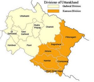
Garhwal Division is the home for Garhwali people. It is the administrative and the north western region of the north Indian state of Uttarakhand. Garhwal Division lies in Himalayan Mountain, and it got its name from the Gahadvala Dynasty of India who was basically Rajputs. On the north it is bounded by Tibet, Kumaon Division on the east, and Uttar Pradesh on the south and the state of Himachal Pradesh in the North West region. It includes the various districts like Chamoli, Pauri Garhwal, Rudraprayag, Dehradun, Haridwar, Tehri Garhwal, and Uttarkashi. The people of this region speak Garhwali language and are known as Garhwali. The administrative hub of Garhwal Division is Pauri. It is often said that Gadhwal was named because of 52 Gadhs 52 chieftains, each chief with his own independent fortress (gadh).
Origin of Garhwal Division
The region of Garhwal Division was previously settled by the Kols. Kols are aboriginal inhabitants of the austro-asiatic physical type and they were later joined by the Indo-Aryan Khas/Khasas who arrived from the northwest by the Vedic period.
The Khas are actually believed to be the descendents of the Eastern Iranian origin of ancient Kamboj. Some believe that the Khasas have arrived from Tajikistan and share some common physical traits with the Tajik people.
Historians doing research on Garhwal and Kumaon say that at the beginning there were only three castes: Khas Brahmin, Silpkar and Khas Rajput. The primary occupation of the Khas Rajput was of the law enforcement and Zamindari. The Khas Brahmin’s main work was to perform religious rituals in the temples and educational centres of the elite class. The Shipkar used to work for the Rajputs and skilled with handicrafts. The surname of the Khas originated from Bahuguna from Bahugani and Pandey from Pandeygaon. However, the cast of the Uttarakhandi people cannot be understood from their surname.
History of Garhwal Division
The Garhwal Kingdom was set up by the Rajputs. One of the chiefs, Ajai Pai, lessened all the small principalities under his own wave and set by the Garhwal Kingdom. He and his successors ruled the Garhwal Kingdom and also the adjacent Tehri Garhwal for an uninterrupted time till 1803 when the place was invaded by the Gurkhas.
The Gurkhas ruled the place for twelve years until serious encroachments by the British Rulers and that led to the fierce war called the Gurkha War in the 1814. After the battle, the territory was fully converted to British District. The British district of the Garhwal was in the Kumaon Divison of the United Provinces.
Geography of Garhwal Division
The geography of Garhwal Division mainly consists of rugged mountain ranges spread in all direction and are separated by narrow valleys which in most cases become ravines or deep gorges. The sole level portion of the district was the small and narrow band of waterless forests between the fertile plains and southern slopes of Rohilkhand. The highest mountain is in the Chamoli District, the main peak is the Nanda Devi (25,643 ft), Kamet (25,446 ft), Chaukhamba (23,419 ft), Trisul (23,360 ft), Dunagiri (23,182 ft), and Kedarnath Temple (22,769 ft). One of the main sources of the Gange River, the Alaknanda, receives the whole drainage of the District. The Alakanda River joins the Bhagirathi River at Devprayag and the united stream gets the name Ganges.
Cultivation and agricultural activity is mainly confined to the direct vicinity of the rivers, which are employed for irrigational purposes.
People of Garhwal Division
The people who have Garhwali roots are known as the Garhwali and they have originated from Indo-Aryan group who mainly inhabited in the Garhwal Himalayas. The Garhwali people speaking the Garhwali language or any other local dialect live in areas like Tehri Garhwal, Pauri Garhwal, Dehradun, Haridwar, Uttarkashi, Rudraprayag, Chamoli, and Bageshwar districts of Uttarakhand, India. Culture of the people is a mixture of local population coupled with the various traditions of the immigrants. Bulks of the people are involved in the tourism, agriculture and the defense industry.
Language of Garhwal Division
The language of the Garhwal division is actually the Central Pahari Language which belongs to the North Zone of the Indo-Aryan and is also native to the Garhwal. Out of 325 recognized language in India, Garhwali is one of them and is spoken by over 2,267,314 people in the Uttarkashi, Chamoli, Tehri Garhwal, Pauri Garhwal, Dehradun, Haridwar and Rudraprayag districts of Uttarakhand. This language is also spoken by people living in other part of the country like Haryana, Punjab, Himachal Pradesh, Delhi, Uttar Pradesh and Bihar.
Kumaon Division, Uttarakhand
Kumaon Division mainly categorised into eight diverse princely states i.e., Baijnath-Katyuri, Dwarhat, Doti, Baramandal, Askot, Sira, Sora, Sui (Kali kumaon). Later on, in 1581 AD after the defeat of Raika Hari Mall (maternal uncle of Rudra chand) with the hand of Rudra Chand all these disintegrated parts came under King Rudra chand and the whole region was as kumaon. Kumaon is one of the two regions and administrative sectors of Uttarakhand, a hilly state in North India, the other one being the Garwal Division. It comprises of the districts of Almora, Champawat, Nainital, Pithoragarh, and Udham Singh Nagar. It is bordered by Tibet in the north, Nepal in the east. On the south is the state of Uttar Pradesh and on the west is the Garwal region. The people of the region are known as Kumaonis and they speak Kumaoni language. The place is also known for the army regiment known as the Kumaoni Regiment.
Important towns of Kumaon are Almora, Pithoragarh, Haldwani, Nainital, Rudrapur, Mukteshwar Kashipur, Pantnagar, and Ranikhet. Nainital happens to be the administrative centre of Kumaon Division and this is where the Uttarakhand high court is situated.
Geography of Kumaon Division
The Kumaon Region consists of massive Himalayan tract along with the two submontane strips known as the Terai and the Bhabhar. The place was impenetrable forest till 1850. But after 1850 there were numerous clearings which attracted large population from the hills who indulged in agriculture and cultivation.
The rivers like Dhauli, Gori, and Kali etc go up chiefly in the southern slope of the Tibetan watershed north of the loftiest peaks, amongst which they make their way down valleys of rapid declivity and extraordinary depth. The main are the Pindari, the Sharda (Kali), and Kailganga, whose waters join the Alaknanda. The river Sharda (Kali) forms the international border between Nepal and India.
The primary trees that are grown in the area are Chir Pine, Pindrow Fir, Alder, Sal, Himalayan Cypress and Saindan.
Some of the important dynasties that ruled the place are Katyuri Raj, Chand Raj, Raikas of Doti, Gorkha Rule and the British Raj.
Martial Race of Kumaon Division
Kumaoni people are famous for their valour and courage. Their honour is legendary. They were never been completely subjected to the dominant and powerful Muslim Rule of Delhi.
It is indeed interesting to note here that the 3rd Gorkha Rifles was known as the Keemaon battalion when it was formed and it included Kumaonis as well as the Garhwalis along with the Gorkhas. The Kumaonis, once accepted as a martial race, were themselves to be recruited in the Hyderabad regiment and displace the native troops, eventually after Independence of India became the Kumaon Regiment. The Kumaon Regiment is known for their tremendous courage and is one of the most decorated regiments of the Indian Army.
Language of the Kumaoni People
Amongst its dialects, the Central Kumauni is spoken in Almora and northern Nainital, North-eastern Kumauni is in Pithoragarh, South-eastern Kumauni is in South-eastern Nainital, and Western Kumauni is west of Almora and Nainital. All together there are 20 dialects spoken in the Kumaon region, namely, Askoti, Sirali, Johari, Majh Kumaiya, Danpuriya, Soryali, Gangoli, Khasparjia, Chaugarkhyali, Kumaiya, Phaldakoti, Pachhai, and Rauchaubhaisi.
Dialects of Kumaoni Language
* Kali Kumaon, Central Kumaoni
* North-Eastern Kumaoni
* South-Eastern Kumaoni
* Western Kumaoni
* Askoti of Askot
* Bhabhri of Ramnagar
* Chaugarkhiyali of Chaugarkha
* Danpuriya of Danpur
* Gangoli of Ganai-Gangoli (Gangolihat)
* Johari of Malla and Talla Johar
* Khasparjiya of Almora
* Kumaiyya of Champawat
* Pachhai of Pali-Pachhhau (Ranikhet, Dwarahat)
* Pashchimi
* Phaldakotiya of Phaldkot
* Rhau-Chaubyansi, (Nainital)
* Sirali of Sirakot (Didihat)
* Soriyali of Sor Valley (Pithoragarh)
* Baitada of Baitadi , Darchula and parts of Bajhang District in Nepal
* Dotiyali of Doti |